Table of Contents
The Mather and Einstein Forewords to the First
Edition
chapter 1 - GEOMAGNETISM, CONTINENTAL DRIFT
AND POLAR WANDERING
chapter 2 - THE FAILURE TO EXPLAIN THE ICE
AGES
chapter 3 - THE FAILURE TO EXPLAIN CLIMATIC
CHANGE
chapter 4 - EVIDENCE FOR THE NORTH POLE IN
HUDSON BAY
chapter 5 - THE VIOLENT LIFE OF THE LAST
GREAT ICE SHEET
chapter 6 - THE SUDDEN MELTING OF THE ICE
SHEET
chapter 7 - EVIDENCE FOR THE NORTH POLE IN
THE GREENLAND SEA
chapter 8 - POLAR CHANGE IN THE REMOTER
PAST
chapter 9 - THE SHAPING OF EARTH’S SURFACE
FEATURES
chapter 10 - THE EXTINCTION OF THE MAMMOTHS
AND THE MASTODONS
chapter 11 - THE EVIDENCE OF VIOLENT
EXTINCTION IN SOUTH AMERICA
chapter 12 - SOME PROBLEMS OF EVOLUTION
The
Ancient Science Series
Maps of the Ancient Sea Kings
The Path of the Pole
The Mystery of Acambaro
Vimana Aircraft of Ancient India & Atlantis
The Return of the Serpents of Wisdom
Lost Continents and the Hollow Earth
Atlantis In America: Navigators of Ancient World
The
Lost Science Series:
The Anti-Gravity Handbook
Anti-Gravity & the World Grid
Anti-Gravity & the Unified Field
The Free-Energy Device Handbook
The Energy Grid
The Bridge to Infinity
The Harmonic Conquest of Space
Ether Technology
The Fantastic Inventions of Nikola Tesla
Man-Made UFOs: 1944-1994
The
Lost Cities Series:
Lost Cities of Atlantis, Ancient Europe & the Mediterranean
Lost Cities of North & Central America
Lost Cities & Ancient Mysteries of South America
Lost Cities of Ancient Lemuria & the Pacific
Lost Cities & Ancient Mysteries of Africa & Arabia
Lost Cities of China, Central Asia & India
Write
for our free catalog of exciting books and tapes.
The Path of
the Pole
by Charles H. Hapgood
ISBN 0-932813-71-2
©1958, 1970, 1999 Charles Hapgood & the Hapgood
Estate
All rights reserved
Printed in the United States of America
First printing September 1999
Published by
Adventures
Unlimited Press
One
Adventure Place
Kempton,
Illinois 60946 USA
auphq@frontiernet.net
Late Director, Cancer Research Center
of the Lankenau Hospital of Philadelphia.
A
Pioneer in Science, a Champion of the Free Mind;
An
Artist in Intellectual Inquiry;
A Fighter Against Those Blights of the
Scientific Community: Smugness, Intolerance
and Materialism.
to the Second Edition
LIKE
many people, I was introduced to Earth’s Shifting Crust not by reading the original text nor through discussion in
the technical journals, but through reading an abridged version in The Saturday Evening Post. This was an unusual experience,
to read something of scientific interest in a family magazine, but what I read
was even more unusual. I found myself reading a reasonably plausible
explanation—the first ever printed—of the major deformations that have racked
the earth’s crust. The abbreviated version so intrigued me that I acquired a
copy of the complete work at the earliest opportunity. The full text proved to
be even more stimulating than its abbreviated predecessor. That first edition
of the book was introduced to the public, through its foreword, by the eminent
scientist Albert Einstein. I must confess that this fact impressed me to a
considerable degree. At the time it never occurred to me that I might be asked
to present the second edition; in fact, this still strikes me as somewhat
incongruous.
Perhaps
at this point I should briefly introduce myself to the reader. I am a mining
geologist and a passable mineralogist, engaged in recent years in teaching
these subjects. Geology, like all branches of science, has become separated
into a maze of specializations. The adherents of one specialization are
certainly more than dimly aware of what is going on in other fields, but can
hardly consider themselves expert in any but their
chosen field. I should not care to be accused of implying, through failure to
admit the contrary, that I am a competent critic of Hapgood and Campbell’s
work. I most emphatically am not.
After
carefully reading Earth’s Shifting Crust, I began
searching through the technical journals and other likely sources for the
discerning criticism that I felt should be forthcoming from experts in the
field. I should have known better than to expect it, I suppose, but hope
springs eternal. A reaction came, of course, and largely it came from men who under ordinary circumstances are both rational and
competent, but their reaction could hardly be described as rational; hysterical
would be a better description. One observed, indignantly, that Hapgood was not
a geologist. Admittedly this is a cardinal sin but hardly one punishable by
scientific excommunication. Another cited, but failed to name, a scientist
whose findings conflict with those of several world-renowned authorities
selected by Hapgood as sources of technical data, and used this lack of agreement
as an incontrovertible condemnation of the entire book.
I
could continue with numerous examples, but this would be pointless. The fact is
that almost without exception Americans commenting on the book couched their
discussion in thick and unwarranted sarcasm, selecting trivia and factors not
subject to verification as the bases for condemnation, seeking in this way to
avoid the basic issues. Only the European reviewers were gracious enough to be
fair, not that they accepted the theory without question, but they were
prepared to offer it its day in court. Nowhere, in all that has been written
about the book, have I found a single authority who has calmly and rationally
offered a clear and documented criticism of the basic theory involved: that
uncompensated masses on or in the earth may cause the earth’s crust to slip
over its core. Frankly, I wish someone would.
In
the years since publication of the first edition of this work we have had,
among other things, the benefit of the research of the International
Geophysical Year. Incorporation of these and other data has had two extremely
important effects upon Hapgood’s theory: first to force a revision of the
theory in relation to the mechanism of crustal displacement, and secondly to
add tremendously to the weight of evidence supporting the thesis that crustal
displacement has occurred. Regarding the first of these I believe that the
author is to be congratulated for having the flexibility to adapt to new facts
as they have become available. For the second, whereas there may have been a
time when the occurrence of dislocations of the crust with respect to the
earth’s rotational poles could have been questioned, I personally feel that in
the light of the data presented by Hapgood in this, the second edition of his
book, such dislocations are no longer a matter of question.
Like
many another engaged in teaching, I have grown weary of apologizing to my
students for teaching time-worn theories whose logic, to use a kind word, is
indefensible. The plain fact is that the logic of all previous theories of the
earth’s deformation is so obviously contrived, the holes are so gaping, that one is inclined to suspect that danger lurks there for
the unwary. Now at last in Hapgood and Campbell’s theory, actually a coalition
of several older and poorly enunciated ideas, we find the first outwardly
reasonable explanation of the observed facts in several major geological
fields. Now I ask-no, I implore—my colleagues, those most competent to assume
the task, to attack this theory with the weapons of well-documented proof. Or,
failing this, let them build upon it to a better,
clearer understanding of the forces that have deformed this planet we live
upon. Let us not bury this idea prematurely through prejudice, as so many
valuable ideas of the past have been buried, only to be sheepishly exhumed in
later years. If it is an unworthy thing let it be properly destroyed; if not,
let it receive the nourishment that it deserves.
F. N. Earll
DEPARTMENT OF GEOLOGY
Montana College of Mineral
Science and Technology
The Mather and Einstein Forewords to the First Edition
THE
most significant change in this book since Albert Einstein wrote his Foreword
for the American edition and Professor Kirtley Mather wrote one for the
British, Spanish, and Italian editions is directly related to the question on
which they both expressed their strongest doubts: the ice-cap “mechanism” by
which I proposed to account for displacements of the earth’s outer shell. Their
doubts have been vindicated by the progress of earth studies in the past
decade. Advancing knowledge of conditions of the earth’s crust now suggests
that the forces responsible for shifts of the crust lie at some depth within
the earth rather than on its surface.
Despite
this change in the character of the proposed explanation of the movements, the
evidence for the shifts themselves has been multiplied many fold in the past
decade. The main themes of the book—the occurrence of the crust displacements
even very recently in geological history, and their effects in forming the
features of the earth’s surface—therefore remain unchanged.
THE
AUTHOR
Foreword to the First Edition
BRITISH,
SPANISH, AND ITALIAN VERSIONS
by Kirtley F. Mather
Professor of Geology, Emeritus,
Harvard University; former
president, The American Association
for the Advancement of Science
THE
idea that the history of the earth involves the shifting of its thin “crust”
from time to time and place to place is certain to receive increased attention
in the next few years. Knowledge is rapidly accumulating concerning the spatial
relations of the crust and the underlying “mantle.” Information regarding the
physical properties of these parts of the stratiform planet is being secured by
geophysicists. Many specific facts are now available concerning local changes
of level and of geographic position of points on the earth’s surface. The
geologic records of the past are replete with items that suggest significant
differences between the latitude and longitude of many places in earlier epochs
and those of the present time.
The
need is clearly apparent for a synthesis of all these many data that would
integrate them in a broadly inclusive scheme and give them unified meaning in
relation to a general principle. In geology, indeed in all scientific disciplines,
analysis must lead to synthesis which in turn must be followed by further
analytical studies in the repetitive cycles of advancing knowledge and
understanding. This is evidently the aim of this thought-provoking book. Its
greatest value will be found in the stimulus it should give to discussion,
debate and controversial argument.
The
concept of crustal shifting as an important and frequently repeated episode in
earth history is not new. But the marshaling of data from many diverse fields of
study and their interpretation in causal terms are sufficiently novel to make
the authors’ ideas worthy of careful study and appraisal. Indeed, certain
aspects of their application of the general concept are radically new and will
undoubtedly lead to healthy controversy. I cannot, for example, accept as valid
certain interpretations made by the authors of some of the facts they cite, but
these are minor matters and do not necessarily invalidate their major argument.
My own confidence in the principle of isostasy leads me moreover to discount
the computation of tangential forces resulting from “off-center” ice caps, but
this is certainly a matter for further study. The results of geophysical
research must accord with the facts of earth history if they are to be accepted
as completely trustworthy.
All of which means that the authors of this novel interpretation of
crustal movements have made a distinctive contribution to geological lore which
should be of interest to all geologists. The
numerous unsolved problems to which Mr. Hapgood directs attention should be the
subjects of intensified debate among scientists in every part of the world. It
should moreover be noted that this book is written in clear, nontechnical
language. Mr. Hapgood has succeeded in bringing the thought within the reach of
every educated layman. It is a readable survey of geological problems that too
long have been the province of specialists alone.
Kirtley F. Mather
JULY 1, 1959
Foreword to the First Edition
by Albert Einstein
I
FREQUENTLY receive communications from people who wish to consult me concerning
their unpublished ideas. It goes without saying that these ideas are very
seldom possessed of scientific validity. The very first communication, however,
that I received from Mr. Hapgood electrified me. His idea is original, of great
simplicity, and—if it continues to prove itself—of great importance to
everything that is related to the history of the earth’s surface.
A
great many empirical data indicate that at each point on the earth’s surface
that has been carefully studied, many climatic changes have taken place,
apparently quite suddenly. This, according to Hapgood, is explicable if the
virtually rigid outer crust of the earth undergoes, from time to time,
extensive displacement over the viscous, plastic, possibly fluid inner layers.
Such displacements may take place as the consequence of comparatively slight
forces exerted on the crust, derived from the earth’s momentum of rotation,
which in turn will tend to alter the axis of rotation of the earth’s crust.
In a
polar region there is continual deposition of ice, which is not symmetrically
distributed about the pole. The earth’s rotation acts on these unsymmetrically
deposited masses, and produces centrifugal momentum that is transmitted to the
rigid crust of the earth. The constantly increasing centrifugal momentum
produced in this way will, when it has reached a certain point, produce a
movement of the earth’s crust over the rest of the earth’s body, and this will
displace the polar regions toward the equator.
Without
a doubt the earth’s crust is strong enough not to give way proportionately as
the ice is deposited. The only doubtful assumption is that the earth’s crust
can be moved easily enough over the inner layers.
The
author has not confined himself to a simple presentation of this idea. He has
also set forth, cautiously and comprehensively, the extraordinarily rich
material that supports his displacement theory. I think that this rather
astonishing, even fascinating, idea deserves the serious attention of anyone
who concerns himself with the theory of the earth’s development.
To
close with an observation that has occurred to me while writing these lines: If
the earth’s crust is really so easily displaced over its substratum as this
theory requires, then the rigid masses near the earth’s surface must be
distributed in such a way that they give rise to no other considerable
centrifugal momentum, which would tend to displace the crust by centrifugal
effect. I think that this deduction might be capable of verification, at least
approximately. This centrifugal momentum should in any case be smaller than
that produced by the masses of deposited ice.
UNTIL
a decade ago the idea that the poles had often changed their positions on the
earth’s surface was regarded as extreme, improbable, and unsound. It was
advocated strictly by cranks. Nobody who was anybody in the scientific world
would have anything to do with it.
Fashions
change. Today every other book dealing with the earth sciences devotes space to
polar wandering and continental drift.
Polar
wandering is based on the idea that the outer shell of the earth shifts about
from time to time, moving some continents toward and others away from the
poles, changing their climates. Continental drift is based on the idea that the
continents move individually.
Many
scientists have come to the point of accepting both these ideas. The evidence
on hand now seems to them to require that the earth’s surface has shifted as a
whole and that continents have also changed their positions relative to one
another.
Up to
the present those who have accepted both ideas have not connected them. They
think of them as independent processes acting simultaneously. A few writers
have suggested that perhaps continental drift causes polar wandering.
This
book advances the notion that polar wandering is primary and causes the
displacement of continents.
Those geologists who have accepted polar wandering and continental
drift, or only continental drift, put the last such change at a long time ago.
This
book will present evidence that the last shift of the earth’s crust (the
lithosphere) took place in recent time, at the close of the last ice age, and
that it was the cause of the improvement in climate.
Two
kinds of evidence are responsible for these changing ideas. New knowledge of
geomagnetism, or the polarization of rocks of the earth’s crust by the earth’s
magnetic field, has led to the discovery that the poles have changed their
places on the surface of the earth at least 200 times since geological history
began. There is little doubt now but that when we have the complete list it
will be twice as long, or even longer.
The
other new body of knowledge has come from new methods of dating events in the
past by the use of radioactive isotopes of a number of elements. An isotope of
carbon (C14, called radiocarbon) has enabled us to
find reliable dates for geological events back to about 65,000 years ago.
Isotopes of other elements are good for dating events two or three hundred
thousand years in the past. Still others date rocks hundreds of millions of
years old.
With
these radioactive dating methods it has been possible to reconstruct the
climatic history of the earth in great detail for the last hundred thousand
years. That is what I shall try to do in this book.
Some
of the results of the chronology of the glacial epoch worked out here are
surprising. For example, I have found evidence of three different positions of
the North Pole in recent time. During the last glaciation in North America the
pole appears to have stood in Hudson Bay, approximately in Latitude 60° North
and Longitude 83° West. It seems to have shifted to
its present site in the middle of the Arctic Ocean in a gradual motion that
began 18,000 or 17,000 years ago and was completed by about 12,000 years ago.
The
radioactive dating methods further suggest that the pole came to Hudson Bay
about 50,000 years ago, having been located before that time in the Greenland
Sea, approximately in Latitude 73° North and Longitude
10° East. Thirty thousand years earlier the pole may have been in the Yukon
District of Canada.
These
ideas are new, and they will at first seem strange, but if the reader will plow
through the necessary factual detail presented in this book, he may find
sufficient proof.
WHEN
it comes time to write an acknowledgment of the assistance received from others
in the preparation of a book, this job is sometimes accomplished in a
perfunctory way; it is a job to be got over with but, at the same time, turned
to advantage. I do not think that this is fair to the essentially social nature
of science. The implication is usually obvious that the book is, in fact, the
work of one or two perspiring and inspired persons, who, by themselves alone,
have persevered against odds to complete an imperishable product. This distorts
the process by which scientific and, indeed, all original work is done.
Scientific research is essentially and profoundly social. Discoveries are not
the product of single great minds illuminating the darkness where ordinary
people dwell; rather, the eminent individuals of science have had many
predecessors; they themselves have been merely the final organizers of materials
prepared by others. The raw materials, the component elements that have made
these great achievements possible, have been contributed by hundreds or
thousands of people. Every step in the making of this book has been the result
of contact with other minds. The work done by hundreds of writers over a number
of centuries has been exploited, and the contributions of contemporary writers
have been carefully examined. The product represents, I should like to think, a
synthesis of thought; at the same time I hope its original elements will prove
valid additions to the common stock of knowledge in the field.
Credit
for the initiation of the research that led to this book belongs, in the first
instance, to students in my classes at Springfield College, in Springfield,
Massachusetts. A question asked me by Henry Warrington, a freshman, in 1949
stimulated me to challenge the accepted view that the earth’s surface has
always been subject only to very gradual change, and that the poles have always
been situated precisely where they are today. As the inquiry grew, many
students made valuable contributions to it in research papers. Among these I
may name, in addition to Warrington, William Lammers, Frank Kenison, Robert van
Camp, Walter Dobrolet, and William Archer.
Our
inquiry first took organized form as an investigation of the ideas of Hugh
Auchincloss Brown, and I am deeply indebted to him for his original sensational
suggestion that ice caps may have frequently capsized the earth, for many
suggestions for research that proved to be productive, for his generosity in
sharing all his research data with us, and for his patience in answering
innumerable letters.
In
this early stage of our inquiry, when I was in every sense an amateur in many
fields into which the inquiry led me, I received invaluable assistance from
many specialists. These included several members of the faculty of Springfield
College, especially Professor Errol Buker, without whose kindly sympathy our
inquiry would have been choked in its infancy. Assistance with many serious
problems was received from Dr. Harlow Shapley, of the Harvard Observatory, Dr.
Dirk Brouwer, of the Yale Observatory, Dr. G. M. Clemence, of the Naval
Observatory, and a number of distinguished specialists of the United States Coast
and Geodetic Survey.
Our
inquiry, in its third year, was involved in a difficulty that appeared to be
insuperable, and from this dilemma it was rescued by an inspired suggestion
made by my old friend the late James Hunter Campbell, who thereafter became my
constant associate in the research project, and my collaborator. I must give
credit to him for having taken hold of a project that was still an amateur
inquiry, and transformed it into a solid scientific project.
When
Mr. Campbell had developed his ideas far enough to assure us that the idea we
had in mind was essentially sound, it became feasible to submit the results of
our joint efforts to Albert Einstein, and we found him, from then on, a most
sympathetic and helpful friend. Throughout an extended correspondence, and in
personal conference, his observations either corroborated our findings or
pointed out problems that we should attempt to solve. With regard to our
inquiry, Einstein made an exception to his usual policy, which was to give his
reactions to new ideas submitted to him, but not to offer his suggestions for
their further development. In our case, with an uncanny sense, he put his
finger directly upon problems that were, or were to be, most baffling to us. We
had the feeling that he deeply understood what we were trying to do, and
desired to help us. Our association with him represented an experience of the
spirit as well as of the mind.
In
the later stages of our inquiry, many distinguished specialists and friends
helped us with particular problems. Suggestions were contributed by Professor
Frank C. Hibben, of the University of New Mexico, Professor P. W. Bridgman, of
Harvard, Dr. John M. Frankland, of the Bureau of Standards, Dr. George Sarton,
Professors Walter Bucher and Marshall Kay of Columbia University, Dr. John
Anthony Scott, Mrs. Mary G. Grand, Mr. Walter Breen, Mr. Stanley Rowe, Dr. Leo
Roberts, Mr. Ralph Barton Perry, Jr., Mrs. Mary Heaton Vorse; Mr. Heaton Vorse,
Mr. Chauncey Hackett, Mrs. Helen Bishop, and Mrs. A. Hyatt Verrill. To Dr.
Harold Anthony, of the American Museum of Natural History, our debt is
enormous. It was he who afforded Mr. Campbell and me our first opportunity to
discuss our theories with a group of specialists in the earth sciences, when he
invited us to talk to the Discussion Group of the Museum. In addition, Doctor
Anthony has helpfully criticized parts of the manuscript and has helped me to
get criticism from other experts. Captain Charles Mayo, of Provincetown,
Massachusetts, in many long discussions over the years, has contributed
innumerable valuable suggestions.
One
farsighted scientist without whose generous help this book in its present form
would have been impossible is David B. Ericson, marine geologist of the Lamont
Geological Observatory. He has contributed many vitally important
bibliographical suggestions, has corrected numerous technical errors, and has
provided needed moral support. I am equally indebted to Professor Barry
Commoner, of Washington University, who not only read the manuscript to suggest
improvements of content and style but also helped me in the preparation of
special articles for publication in the technical journals. Mr. Norman A.
Jacobs, editor of the Yale Scientific Magazine,
published the first of these articles.
During
the last year I have received enormous assistance from Mr. Ivan T. Sanderson,
who, as a biologist, has read the manuscript with a critical eye for misuse of
technical vocabulary and for weaknesses in presentation. I have received
invaluable help from Professor J. C. Brice, of Washington University, who has
criticized the whole manuscript from a geological standpoint. I am deeply
indebted to my aunt, Mrs. Norman Hapgood, for the first complete translation
from the Russian of the report of the Imperial Academy of Sciences on the
stomach contents of the Beresovka Mammoth, to Mrs. Ilse Politzer for the
translation from the German of Einstein’s letter of May 3, 1953, and to Mrs.
Maely Dufty for assistance with the translation of his foreword into English. To many personal friends, in addition to those mentioned, I
owe thanks for encouragement and for suggestions that often turned out to have
major importance. I am indebted to John Langley Howard for his assistance with
the illustration of this book, to Mr. Coburn Gilman, my editor, for his
innumerable constructive suggestions and his understanding spirit, to Mr.
Stanley Abrons for his painstaking work in preparing the glossary, and to Mr.
Walter Breen for preparing the index.
In
the final typing of the manuscript Miss Eileen Sullivan has had to encounter
and survive difficulties and frustrations that only she and I can have an idea
of. I am very grateful for her help.
Grateful
thanks are extended to all publishers and individuals who have consented to the
use of selections or illustrations, and in particular to the following:
Columbia
University Press, for quotations from George Gaylord Simpson, Major
Features of Evolution; Thomas Y. Crowell Co., for a passage from Frank C.
Hibben, The Lost Americans; Dover Publications, Inc.,
for quotations from Beno Gutenberg, Internal Constitution of
the Earth (paperbound, $2.45); W. H. Freeman & Co., for quotations from
Krumbein and Sloss, Stratigraphy and Sedimentation ;
Alfred A. Knopf, Inc., for quotations from Hans Cloos, Conversations
With the Earth; N. V. Martinus Nijhoff’s Boekhandel en
Uitgeversmaatschappij, The Hague, for quotations from J. H. F. Umbgrove, The Pulse of the Earth; Prentice-Hall, Inc., for quotations
from R. A. Daly, The Strength and Structure of the Earth;
Science, for quotations from various issues of this magazine; William Sloane
Associates, Inc., for quotations from Thomas R. Henry, The
White Continent (Copyright 1950 by Thomas R. Henry); University of Chicago
Press, for quotations from various issues of the Journal of
Geology.
Charles H. Hapgood
KEENE TEACHERS COLLEGE
OCTOBER, 1957.
In
the new, revised edition of EARTH’S SHIFTING CRUST under the title The Path of the Pole I am especially indebted to Mr. Oppé
and Mr. Delair for the great contribution they have made in researching the
difficult field of Pleistocene history in South America, and to Fred Earll for
his foreword, to say nothing of his helpful advice in preparing this edition. I
should also thank those hundreds of research workers who have, by their efforts
in geophysical research and in the extension of our knowledge of the past
through the new techniques of absolute dating, made possible my own work.
C. H.
August, 1970
“We know that there is no absolute knowledge, that there are only
theories; but we forget this. The better educated we are, the harder we believe
in axioms. I asked Einstein in Berlin once how he, a trained, drilled, teaching
scientist of the worst sort, a mathematician, physicist, astronomer, had been
able to make his discoveries. ‘How did you ever do it,’ I exclaimed, and he,
understanding and smiling, gave the answer:
“ ‘Bay challenging an axiom!’ ”
Lincoln Steffens, Autobiography (p. 816)
GEOMAGNETISM, CONTINENTAL DRIFT AND POLAR WANDERING
1. DO THE POLES MOVE?
WHAT do
we mean by polar wandering? This phrase may mean several different things. It
may be thought to mean a shift in the position of the axis of the earth.
Everyone has seen pictures of the solar system, with the earth, the other
planets, and the sun shown in relationship to one another. The earth is always
shown slightly tipped. Its axis does not run straight up and down at right
angles to the plane of the sun’s equator, but slants at an angle. Any change in
this angle, in the position of this axis, would be very important for us. It
might mean, for example, that the South Pole would point directly at the sun.
We would then have one hot pole and one cold pole. The hot pole would never
have any night, and the cold pole would never have any day. The occurrence of
this kind of polar shift has seldom been suggested, for the reason that no
force capable of shifting the axis has ever been imagined, other then,
possibly, a major planetary collision.
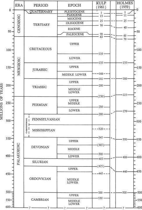
Fig. 1. The
geological table.
A
second way of shifting the poles would be not to change the direction of the
axis (let it point to the same stars as before) but merely to shift the earth
around on its axis so that different places on its surface would be at the
poles. This suggestion also has run into difficulties. The main obstacle to
such a shift is the stablizing effect of the equatorial bulge of the earth. The
earth is not a true sphere, of course, but a slightly flattened spheroid. The
polar flattenings are balanced by a bulge at the equator. The diameters of the
earth through the poles and through the equator differ by about 13 miles. The
extra mass around the equator, rotating at a very rapid rate, acts like the rim
of a gyroscope to keep the earth steady on its axis. The earth is not
absolutely steady—it wobbles a little, its off-center path having an average
radius of about 50 feet and completing a cycle in about 14 months. But this
wobble is not important for us in the present discussion.1
During
the nineteenth century some of the titans of geology, including James Clerk
Maxwell (296) 2 and
Sir George Darwin (son of Charles Darwin), considered this problem, and they
decided that the stabilizing effect of the equatorial bulge was so great that
no conceivable force originating within the earth could make it shift on its
axis. They therefore dismissed the idea of any shift of the poles as impossible
and, in fact, not worth discussing. Their influence was sufficient to make sure
that nobody until now would seriously consider polar shifts.3
A
third way to conceive of polar wandering is through the sliding of the earth’s
whole outer shell over semiliquid layers below. This idea was suggested long
ago, like most good ideas, but the fellow who first advanced the notion, Damian
Kreichgauer (256), did not have enough influence to impose the idea on his
contemporaries. This theory requires only two things: first, that the material
under the earth’s rigid crust (more properly called the “lithosphere”) be
sufficiently liquid, and second, that there should be available a force
sufficient to set. the outer shell in motion and keep it moving for
considerable distances.
Still
another way to change the positions of the poles relative to the continents is
to move the continents. This is now a very popular way of explaining things,
and we shall discuss it below. However, first we must ask: What is the evidence
that the poles really have changed their positions, in one way or another,
relative to the various parts of the earth’s surface, especially the continents?
People have been claiming to have evidence of such changes for a hundred years,
but only recently have we obtained evidence that really seems indisputable. The
new evidence has come from studies of the past history of the earth’s magnetic
field.
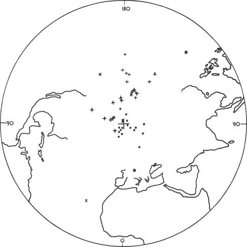
2. THE GEOMAGNETIC EVIDENCE
The
magnetic field of the earth is what influences the compass to point north. The
compass needle does this because it is composed of iron, and iron is a magnetic
substance; that is, a substance which will itself become magnetic when exposed
to a magnetic field, and will therefore align itself with the lines of force of
the earth’s field. What is true of iron in the compass needle is also true of
the iron in rocks composed of minerals containing iron.4 The tiny iron particles in these
rocks also take on a magnetization; they become miniature compasses lined up
with the earth’s magnetic field.
The
compass needle, if it is free to move in all directions (vertically as well as
horizontally), will start pointing gradually downward as the ship or plane
bearing the compass approaches the north or south magnetic pole. At the north
magnetic pole its north-pointing end will point straight down, and, of course,
its south-seeking end will be pointing straight up. At the South Pole this
would be reversed. At the magnetic equator the compass needle would lie level.
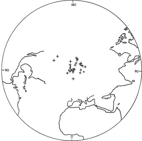
Fig.
2. Pole positions determined from European rocks of Tertiary
and Quaternary Periods.
When
iron-bearing rocks have become magnetized they are actually more informative
than the mariner’s compass. They indicate the direction of north as the ship’s
compass does. But by the angle of their dip they also indicate how far away the
pole is. This means they indicate the latitude. The
horizontal angle is called variation; the dip is called inclination. The variation gives the longitude of the
sample relative to the present magnetic pole, and the inclination gives the
latitude. The magnetic rocks adopt the direction of the earth’s field at the
time that they are formed, and in many cases they preserve their directions of
magnetization indefinitely.
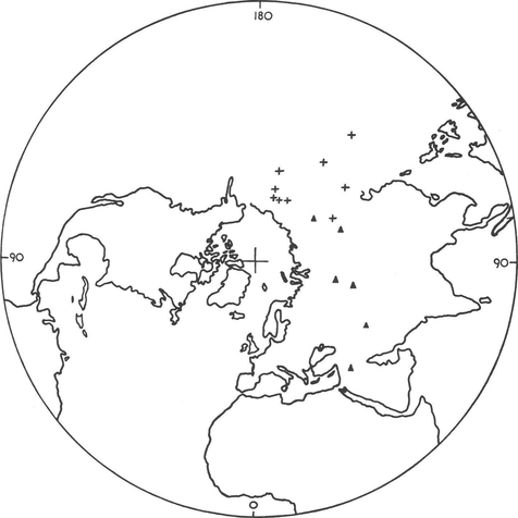
Fig.
3. Pole positions determined from European rocks of Mesozoic
Era.
Of
course, there are many problems. Local movements of the crust may invalidate
the evidence by moving the slab of rock containing the sample hundreds of miles
along a major fracture, like the San Andreas Fault in California. The sample,
through deep burial, might have been subjected to heat and pressure sufficient
to destroy its magnetization or alter the direction of its field. There are
other factors that may operate to invalidate a sample. Most of these, however,
being local, may be eliminated by the simple means of basing estimates of the
position of a pole at a particular time on many samples taken from different
places far apart, in different countries or continents.
Fig.
4. Pole positions determined from European rocks of Late
Paleozoic Era.
Another
problem arises from the fact that the magnetic field of the earth does not stay
put. It is in constant motion, having, for one thing, a steady westward drift.
Geophysicists studying this, however, have concluded that over a period of a
few thousand years the earth’s field returns to its original position, and that
the average position of the magnetic pole over the whole period will coincide
with the earth’s axis of rotation.
It is
simply a question, then, of taking samples from a rock thick enough to represent
the sedimentation of several thousand years. If the samples come from lava
flows, they have to be taken from successive lava flows indicated as having
occured fairly close together in time.
Fig.
5. Pole positions determined from European rocks of Precambrian
and Cambrian Periods.
When
many samples are assembled, and the results are averaged to eliminate the
errors due to local factors or to the “secular” variation of the earth’s
magnetic field, and when it has become reasonably certain that no factor has
intervened to change the original direction of the magnetization, we begin to
have a fairly reliable indication of the position of the pole at the time when
the rocks were laid down. If we know approximately when they were laid down
(dating them by the included fossils or by one of the methods of “absolute”
dating now available) we can assign a date to the particular pole position.
Fig.
6. Pole positions determined from Asian rocks of the
Ordovician to the Quaternary Period.
It is
obvious, from what I have said above, that there are booby traps, so to speak,
for the unwary worker in this field. Nevertheless a vast amount of research has
been done, and the state of the science has advanced until we can say that the
present findings of pole positions are reasonably reliable. Margins of error
are usually allowed. They are indicated by “uncertainty ovals” drawn around
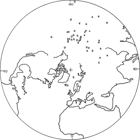
each pole position. The reader will observe these ovals in Figure 8. Table 1
lists a great many positions for the North Pole, found from samples of magnetic
rocks from all the continents (111a:4-46). Each of these positions has been
found by averaging the directions from many samples in the same geological
formation, or in geological formations of the same age from other localities.
The uncertainty ovals are statistically determined and have 95% accuracy. It is
the opinion of specialists that the findings are reliable. What the findings
indicate is that the poles have changed their positions relative to the earth’s
surface many, many times throughout the history of the earth.
Fig.
7. Pole positions determined from Indian rocks of Mesozoic
Era and Tertiary Period.
TABLE 1
Number of Positions of the North Pole
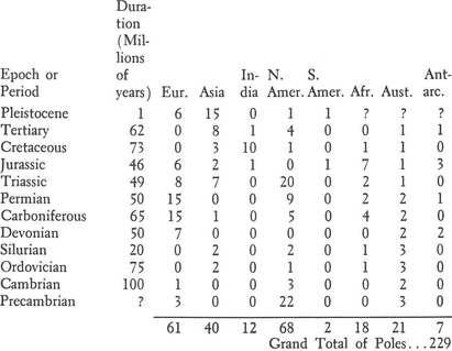
We
see that 229 pole positions are indicated on this table. It is assumed that
some of these may be duplications; that is, the same pole indicated from
different continents, which is shown as a different pole because of continental
drift. How many of these poles may be duplicates? In order to reduce the
likelihood of duplicates I have listed, in Table 2, the poles found for each
geological period from rock samples from one continent only. Since, obviously,
the number of poles in any one geological period would have to be at least
equal to the highest figure from any one of the continents, I have selected the
continent showing the most pole positions for each particular period.
TABLE 2
Pole Positions Shown by Samples from One Continent
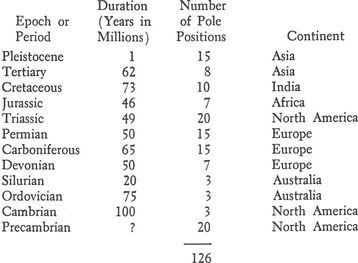
It
seems obvious that the number of pole positions so far determined, though large,
is not nearly enough for any but tentative conclusions about continental drift.
The following table illustrates this by giving the average time intervals
between the poles so far determined for the different geological periods.
TABLE 3
Time Intervals Between Pole Positions
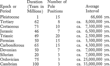
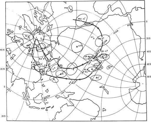
Fig. 8. Polar wandering
curves based on European and North American rocks. (Mean
poles based on all determinations are underlined. European poles are denoted by
dots and American poles by triangles and crosses.)
It is
obvious that such inequalities in average intervals between polar shifts can
have no relation to reality. If there is any regularity (even approximate) in
the intervals between polar shifts, the minimum period indicated in this table
is more likely to reflect the truth than are the very long periods. It is
perfectly obvious that for very long remote geological periods we have
virtually no evidence. For the Pleistocene it seems we have an average interval
of about 70,000 years between polar shifts. I shall show, in the following chapters, that this may not be very far from the mark. The
very long intervals indicated for the older geological periods I think reflect
merely our lack of information.
In
this book I will give special attention to recent geological time; that is, to
the Pleistocene Epoch. It is commonly thought that no polar shifts could have
occurred in this recent period. It is the general impression that the poles
have been in their present locations for at least several million years.
Magnetic evidence in contradiction of this view, however, now exists. This
evidence has resulted from studies of volcanic deposits in Japan by Nagata,
Akimoto and others (318b) and from Soviet studies (249a). The Japanese samples
were taken from the Omura-Yama group of volcanoes in the North Izu and Hakone
volcanic region on the east coast of Honshu. Table 4, below, gives positions of
the North Pole during the Pleistocene Epoch in reverse chronological order,
beginning with the most recent based on Japanese rocks. Column 3 gives the
radius of the oval of 95% certainty for each position. No precise datings of
the different lava flows were possible. It is therefore not possible to average
out the secular variations of the magnetic pole positions indicated, and they
do not necessarily indicate the positions of the geographic poles. In some
cases they may indicate the temporary position of the pole at the time of a
lava flow, when the pole was actually in motion from one position to another.
TABLE 4
Pleistocene Positions of
Magnetic North Pole from Japanese Samples
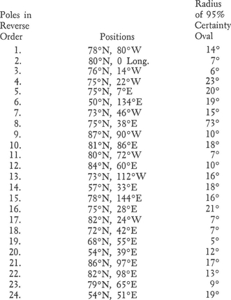
It is
interesting to note that Table 4 indicates that a complete reversal of the
earth’s magnetic field occurred twice during the period.
The
authors, attempting to interpret the data of this table as a continuous curve,
state: “On smoothing out the fluctuations whose periods are shorter than the
period of each volcanic activity, the position of the north pole of the
geomagnetic centered dipole can be estimated to have shifted from 72° N, 86° E
to 81° N, 32° W during the whole Quaternary period” (318b:263). This
interpretation of their data will be discussed below (Chapter VII, page 183).
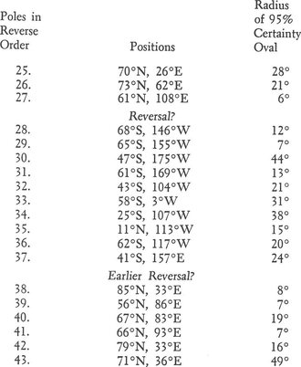
The
Soviet findings, as given in Table 5, are not nearly as complete, and their
chronological order is uncertain. Nevertheless they indicate considerable displacements
of the north magnetic pole.
TABLE 5
Pleistocene Positions of the North Magnetic Pole after
Khramov et al. (249a)
5,6
The
geomagnetic data from older geological periods discussed above (Figs. 2-8, pp.
5-13) have inspired geologists to attempt to construct curves for the path of
the pole for tens or hundreds of millions of years. It seems to me that the
evidence is insufficient for the construction of curves in the older periods.
It appears that even in the short period of the last million years such a curve
can be constructed only at the cost of sacrificing much of the detail of the
evidence. I do not think that those who assume this sort of progressive pole
wandering over considerable periods have stopped to work out the logical
consequences of their assumptions. What does the idea of a curve involve?
In
the first place it involves a continuous motion, or, in the case of
interruptions or standstills, the resumption of the motion in more or less the
same direction. Changes of direction would have to be gradual in order to give
us the long, smooth curves indicated by the authors of the diagrams. We must
remember that if the lithosphere is set in motion over the asthenosphere
immense forces have been involved. A powerful momentum has been transferred to
the lithosphere. An equal force will be required to stop it. But stop the
lithosphere did, each and every time after a shift, long enough to form the
sedimentary rocks that were to become magnetized in the direction of the
earth’s magnetic field at the time. It is obvious from the methods used in the
fieldwork that the polar positions were stable for periods of thousands of
years, just as they have been in our day ever since men began to make
astronomical records in Egypt and in Babylon.
What
is the probability that after the lithosphere had been brought to a halt, with
each stand still lasting an unknown—perhaps considerable—length of time, that
it would resume motion in the same or very nearly the same direction? And what
sort of force within the earth could act intermittently in this way? The
mechanism I propose to suggest a little later on in this chapter will be one
that can account for the starting and stopping of the movements, but it is one
that will not act continually in the same direction. According to it, the path
of the pole would more likely be a sort of zigzag, with the direction of each
new movement determined by the balance of forces within the earth at the
particular time. The zigzag path would tend to insure the pole’s remaining
within the general area for a considerable time and taking long periods of time
to migrate great distances. In Chapters IV, V, and VI and VII I shall present
evidence to demonstrate this very sort of motion of the pole in the Pleistocene
Epoch.
There
are three possible interpretations of the geomagnetic evidence. We can assume
polar wandering, continental drift, or a combination of the two. But in order
to be able to judge the relevant evidence we must, before we proceed, take a
look at what is known about the inside of the earth, where unknown forces have
operated to bring these things about.
3. BRIEF SURVEY OF THE EARTH’S
STRUCTURE
There
is not much that we know about the inside of the earth, because we are
unfortunately restricted to living on the outside of it. We must deduce what we
know from mining and oil drilling activities, seismic waves from earthquakes or
artificial explosions, and principles of physics. The subject is wrapped in
uncertainty. Therefore, it is natural that there should be differences of
opinion—opposing groups of scientists devoted to different notions. However,
among the uncertainties there are some points on which most scientists are
agreed. I will confine myself here to giving in a condensed form the consensus
of geological opinion on the structure of the earth.
a. There is an outer shell, composed of solid, crystalline rock about 30 to 40 miles thick, extending down to the melting points of the rocks. This layer is properly called the “lithosphere,” although it is sometimes called the earth’s “crust.”
b. The lithosphere is theoretically arranged in layers, which include loose sedimentary material on top, then rocks, called “sedimentary rocks,” made of such sediments, then rocks originally made of such sediments, which have been melted and partly fused, called “metamorphic rocks.” Generally below these sedimentary and metamorphic rocks are heavier granitic rocks (also partly sedimentary in origin) and finally still heavier basaltic rocks. These layers are not at all uniform in thickness; the layering is only a general tendency. Light rock exists at all depths in the lithosphere, even on the bottom of it. The lithosphere has been churned up all through its history by processes of mountain building, and the like.7
c. At a depth of about five miles under the ocean bottoms and two or three times that under the continents, there is a discontinuity called the Moho,8 that has been much in the news lately. Below this break the material differs in some ways from the material above, but just how we do not know. Some scientists believe there is a chemical difference. Others maintain that the difference is only a change of phase. It is, of course, true that heat and pressure can change the appearance, density and properties of a substance without changing the chemical composition. Everyone knows that graphite, if placed under sufficient pressure and heated, can be turned into diamond. There are some reasons for favoring the phase theory about the Moho. For one thing, it would be hard to reconcile a chemical difference at the Moho discontinuity with the folding of the lithosphere to its full depth in mountain building.
A few years ago some scientists conceived the idea of boring a hole down to the Moho. Congress approved a large appropriation for the operation, and there was hope for an answer to this question of chemical versus phase change. Unfortunately politics stepped in. The contract for the operation was taken away from a corporation that was used to oceanographic work and given to a Texas corporation less used to working with such problems. Difficulties developed and the project was abandoned. An interesting book, however, has been written about it (24a) and perhaps some day the project will be carried through (probably by the Russians).
This whole question of the Moho has produced some unfortunate confusion. Some scientists have fallen into the habit of regarding this Moho discontinuity as the bottom of the “crust.” The crust used to be regarded as synonymous with the lithosphere; that is, the whole crystalline shell of the earth extending down to a depth of 30-40 miles. This definition has been abandoned. It has become the practice to lump everything below the Moho under the general—and therefore meaningless—term “mantle.” Of all the ambiguities in current scientific literature the confusion of the terms “crust” and “mantle” is the worst. It has confused the scientists themselves, as we shall see. One point must be made clear: The Moho does not mean the lower limit of the crystalline rocks. The rigidity and strength characteristic of those rocks continue to a much greater depth.
This confusion is related to another one, concerned with the strength of the lithosphere. Some scientists work from the premise that the lithospheric shell, the outermost shell of the earth, is weak; they even treat it mathematically as if it were a liquid! This is an error which comes from the failure to distinguish clearly between two different qualities of crystalline rocks, two different kinds of “strength.” There is tensile strength, but there is also another kind, which we may call crushing strength. It is quite true that the rocks of the lithosphere do not have the tensile strength of steel. You could never make I beams of rock. It is plain that you can shatter rock with comparative ease. Crushing strength is an entirely different matter. The crushing strengths of rocks differ, naturally, with chemical composition, but granite and basalt, for example, have enormous crushing strength, as anyone running a car into a granite cliff will discover. The lithosphere, according to Dr. Harold Jeffreys, the dean of British geophysicists, is rigid enough to transmit stresses across any distance (238:288). We shall see that this crushing strength of the lithosphere, including that part of it that lies under the oceans, will be very important for various aspects of polar wandering and continental drift.
It is important to note that the strength of rocks depends on their crystalline structure. The strength of crystals varies with their chemical composition. Ice crystals have little strength, but granite and basalt crystals are very strong. The rocks of the earth’s crust are composed of billions of tiny, strong crystals that interlock with one another, pointing in all directions, not in neat arrangements. These strong, rigid, interlocking crystals prevent the molecules of the rocks from sliding past one another, as they do in liquids.
d. Below the lithosphere there lies a thick layer of rock that is soft, amorphous, perhaps nearly liquid. This layer begins at the point where the earth’s heat reaches the melting points of the rocks, and this is thought to be at a depth of 30 to 40 miles, as already mentioned, both beneath the continents and beneath the ocean basins. This soft layer is called the “asthenosphere” from the Greek word for “weakness.”
The evidence for this soft layer is of various kinds. Daly cited geological evidence from mountain building and from the rebound of areas that were depressed under the ice load in Europe during the ice age (97); Gutenberg calculated that the soft layer extended from 60 to 120 miles down, but this was revised by Anderson to from 35 to 150 miles (1c:54). Vacquier has pointed out that magnetic anomalies, showing strike-slip displacements of the ocean floor (to be discussed later) suggest a soft layer underneath:
The existence of displacements in the ocean floor of magnitude comparable to the distances that continents are presumed to have drifted, indicates that there must be a mechanism for lubricating, so to speak, these displacements, so that whole continents, and in the present case stretches of oceanic crust several hundred kilometres long remain virtually undistorted by the motion. (363a:143).
Chadwick presents various arguments for the existence of the soft layer (363a:215,225).
This soft material of the asthenosphere may be technically a liquid, but that doesn’t mean that it is as liquid as water. It may be more like a stiff tar; the difference is a matter of viscosity. The viscosity of a liquid is its resistance to flow. Water has low viscosity. Melted rock, as we see it, for example, in lava flows, has higher viscosity. It is true also that pressure increases viscosity, because it presses molecules more closely together and makes it harder for them to flow past one another. The asthenosphere, then, may be fairly stiff, even right below the lower limit of the lithosphere, and probably grows stiffer with depth even though the heat, which is also assumed to increase with depth, tends to counteract the effects of pressure by reducing the viscosity. Studies of the velocity of earthquake waves suggest that the viscosity increases in the lower levels of the asthenosphere until at a depth of 180 to 250 miles the material may behave in some respects like a solid. Again, we shall find all these facts vital in evaluating theories of polar wandering and continental drift.
There are still other factors to be considered with respect to the asthenosphere, which, as we have just seen, in its lower parts may not be weak at all. So far as viscosity is concerned, chemical composition is just about as important as heat. Each chemical substance has its own melting point, its own degree of viscosity under the opposing influences of heat and pressure. This makes it impossible to be sure exactly where the lithosphere ends and the asthenosphere begins, or to know what the viscosity of the asthenosphere is. Such information is not at present available, though there are indications. We can make deductions from some lava flows as to the chemistry at the bottom of the lithosphere, but unfortunately lava flows differ in chemistry. Dr. Reginald Daly of Harvard reasoned that the asthenosphere right under the bottom of the lithosphere had to be virtually a liquid to account for the easy response of the lithosphere to the growth and melting of ice caps (97:19,389).
As if the situation were not already difficult enough, it appears that two other qualities of matter must be taken into account. One of these we call “plasticity,” and the other, already mentioned, is change of phase. The term “plastic” is often used these days by writers on geophysics as if it were synonymous with viscosity. But the plastic behavior of rocks has nothing whatever to do with viscosity. It is, in fact, an opposite kind of behavior. The difference between them is all-important for the issues we are discussing. The difference between them is that if you apply pressure to a viscous material it will yield gradually at a speed proportional to the pressure applied. Therefore, with twice the pressure, the material will yield twice as fast. Plastic deformation works differently. Every chemical solid has a plastic limit. It will behave like a solid until the pressure reaches that limit. Then it yields suddenly and completely. It does not yield at a rate proportional to the applied force. It is almost like the breaking of the branch of a tree. When the branch breaks, its strength is suddenly and entirely gone.
This type of plastic behavior deep in the earth permits very sudden events to take place at a level where the viscosity is very high. According to Daly, who based his opinion on laboratory experiments carried out at Harvard by Bridgman (97:403), this is the true explanation of “deep focus” earthquakes. Completely unlike viscosity, the plastic strength of materials decreases steadily with increasing pressure. It therefore reaches a low point in the bottom levels of the asthenosphere, and this permits the fracture and slip of materials under great pressure, as were observed in the above-mentioned experiments in the laboratories at Harvard.
Some scientific writers, failing to take into account the plastic behavior of materials, have made the error of assuming that the deep-focus earthquakes mean that the crystalline structure of the lithosphere extends to depths of 300 to 430 miles, an impossibility unless the intensity of the earth’s heat at these depths has been grossly exaggerated.
The earth’s heat, unfortunately, is another mystery. Formerly it was thought that it originated with the planet, and was greatest in the earth’s core. Now it is thought that most of the heat originates from the decay of radioactive materials in the lithosphere, and very little comes from greater depths. We have no direct evidence that can settle this matter. It is quite possible that the heat gradient we observe in deep mines, on which our estimates are based, does not extend all the way to the earth’s center. If that is true it will pull the rug out from under many of our ideas.
e. In addition to these various uncertainties, we must also consider change of phase. As already noted in the case of the Moho, a chemical substance under different conditions of heat and pressure may change state. It may expand or contract, or a change of phase may permit it to enter into chemical reactions with other minerals which could not have occurred in its original state.
It seems that such a layer has been discovered in the asthenosphere at a depth of about 100 miles. According to the Soviet geophysicist V. V. Beloussov (25a), chemical processes at this depth, made possible by change of phase, are changing heavier into lighter rock, thus causing gravitational instability as the lighter rock tries to rise to the surface. Beloussov has named this the “wave-guide layer.” Observations by the American geophysicist Frank Press are in general agreement. Press finds (from satellite observations) that this layer is a very liquid one (349c). It seems that if the earth’s outer shell does slide as a unit over the interior, this is the most likely level at which the movement can occur.
f. Below the wave-guide layer the material continues to increase in viscosity, because of the increasing pressure, until it reaches the state that Professor Daly referred to as a “pressure solid.” Below this point (at a depth of about 430 miles) earthquakes do not occur. It would seem that here viscosity has finally conquered plasticity. The exact depth at which the pressure solid begins is uncertain, but it is vital for the various issues involved in continental drift.
g. Finally, at a depth estimated at 1800 miles, we arrive at the earth’s core, containing, according to some experts, two layers: an outer one, solid, and an innermost one, liquid. The innermost core may or may not be an iron core; there may or may not be rapid currents in it; it may or may not have any connection with the earth’s magnetic field. If we discuss these questions it is only to present differing views: There is no consensus.
4. CONTINENTAL DRIFT: THE THEORY OF ALFRED
WEGENER
Alfred
Wegener, who first drew attention to the idea of continental drift, was a good
scientist, though not a geologist. He had found quantities of evidence of
fossil flora and fauna that could not, in his opinion, be reconciled with the
present positions of the poles. Inasmuch as the authorities, such as George
Darwin and Maxwell, forbade any thought that the axis had moved, or that the
earth had shifted on its axis, Wegener suggested that the continents had moved.
This would have precisely the same effect as polar shift, for it would mean
that at different times the same areas might be found in very different
latitudes.
Wegener
imagined that the continents, formed of light sedimentary and granitic rocks,
were floating in the heavier basaltic material of the ocean bottoms. He thought
he saw evidence, in the shapes of the continents, that they had once formed a
single land mass, which had split so that pieces could go drifting off over the
ocean bottoms. He thought of the ocean bottoms as composed of soft, amorphous
or viscous rock. From a vast amount of fossil evidence of the plant and animal
life of the past he imagined that he could reconstruct the paths of the
continents over long periods of time. He proposed to explain the mystery of ice
ages by this theory. He suggested that during the last ice age in the Northern
Hemisphere, Europe and America had lain together near the North Pole, but that
since then they had drifted away from the pole and each other.
Wegener’s
theory had great appeal—not because all the evidence supported it, not because
the authorities were open-minded about it, not because its mechanics were very
plausible, but because it was the only theory that, at the time, could make
sense of the evidence of the fossil flora and fauna.
A
number of weaknesses in this theory were gradually revealed. As knowledge of
the ocean bottoms increased it was discovered that the rock under the oceans,
which Wegener thought to be plastic enough for the continents to drift over it,
was in fact very rigid, and indeed stronger than the rocks of the continents.
This meant that the continents could not drift without displacing and pushing
to one side a layer of rigid rock estimated to be twenty miles thick. It
therefore seemed to be impossible for continents to drift. Jeffreys, basing his
opinion on the evidence for a rigid and comparatively strong ocean floor, said,
“... There is therefore not the slightest reason to believe that bodily
displacements of continents through the lithosphere are possible” (239:346).
The geophysicist F. A. Vening Meinesz, according to Umbgrove, conclusively
proved the considerable strength of the crust under the Pacific (420:70).